


Huntington Blueway Trail Guide presented to public, includes 12 family-friendly trails for paddlers
The draft plan for the Huntington Blueway, a project developed by the Town of Huntington in collaboration with Cornell Cooperative Extension of Suffolk County, was presented to the public via Zoom this past Tuesday, October 24.
Blueways are non-motorized boat and paddling routes that combine water-based recreation with environmental awareness. The Huntington Blueway trails run from the head of Cold Spring Harbor through the Long Island Sound and the Huntington-Northport Bay complex, to the mouth of Fresh Pond in Smithtown Bay.
The project includes the development of trail maps that feature access points, amenities, and stopovers, highlighting natural and cultural heritage points of interest that have been assembled and geolocated to create the Blueway Trail Guide. The guide will be available to users through an online interactive web map, a mobile app that detects participants’ locations while on the trail, and a clickable video tour that provides audio descriptions for points of interest.
According to the project website, the trail guide is “creating physical linkages between community centers, waterways, parks, open spaces, and historic, scenic and cultural sites.” It includes “creature features” that provide information on the town’s coastal fish and wildlife habitat areas, such as Northport’s Phragmites Park, Bird Island, Clam Digger’s Hole, Jerome A. Ambro Memorial Wetland, and Eatons Neck Point.
Some highlighted creatures include the diamondback terrapin, horseshoe crab (and their spawning areas), blue crab, osprey, great blue heron, great egret, snowy egret, piping plover, bald eagle, harbor seal, and red fox. Native plants, including smooth cordgrass, prickly pear cactus and dwarf glasswort are also featured.
The guide also includes cultural and historical points of interest that can be visited on the blueway or from access points throughout the route. Some notable locations include the Jesse Carll Shipbuilding Shop, which stood north of the Bayview Avenue and Main Street intersection and was one of the shipbuilding titans in the area during the late 19th century; Makamah Beach, named after Chief Makamah, a leader of the Matinecock Native Americans; and the Thompson Building, where the Edward Thompson Company published the country’s first legal encyclopedia.
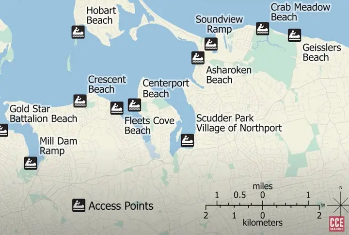
The Huntington Blueway trails map includes routes geared toward families or less experienced paddlers. There are 12 designated family-friendly trails on the blueway, located at and around West Neck Beach, Billy Joel Park, Gold Star Beach, Crescent Beach, Hobart Beach, Fleets Cove Beach, Centerport Beach, Asharoken Beach, the Soundview ramp, and Crab Meadow Beach. Caution areas are indicated on the map guide, which include where there’s heavy motorized boat traffic.
To view the Huntington Blueway draft plan, click here. To access the tour on mobile, download the Locatify Smartguide app and search “Huntington Blueway.” Public comments on the draft guide will be accepted through December 15 here.
Don’t miss a story
Get the latest news delivered to your inbox.


